DEAL ISLAND, Md. — Steps from the water’s edge, men stumble groggily into the glow of Arby’s General Store, indifferent to the shifting ground beneath them. Waves lap the shore this summer morning as the sea steadily advances on an island lurching toward extinction.
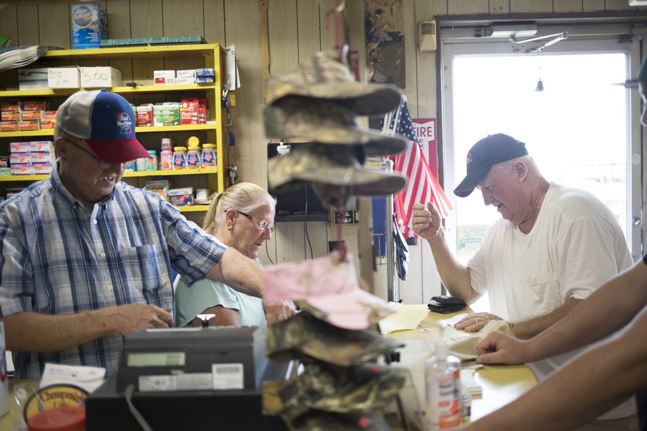
By 4:30 a.m., Arby Holland has fixed the day’s first pot of coffee and is wondering how, after 33 years, he still has the fortitude and finances to run a weather-worn operation that is part tackle shop, part convenience mart and part watering hole.
A sign out front teases: “It ain’t the end of the world, but you can see it from here!”

Pennsylvania
New Jersey
Maryland
Washington
DE
Atlantic
Ocean
Virginia
50 Miles
Here is Deal Island, where the watermen hop on their boats before daybreak in search of crabs, oysters and any fish that the brackish waters of the Chesapeake Bay off Maryland will nestle into their nets. The blue crabs — the most prized — are harvested, stripped of their tender meat and shipped to restaurants in Baltimore, Washington and New York.
Here is also where a remarkable transformation is taking place: Scientists estimate that the surrounding waters of the Chesapeake region have risen a foot in the past century. As global sea levels continue to climb, the bay water could grow 2 feet by 2050 and another 3 feet or more by 2100, models predict. At that point, Deal Island would be almost entirely submerged.
The People of Deal: Fighting For Survival
For residents, the time to defend their home is now. Unlike in other natural disasters, like the hurricanes that ravaged Houston and Puerto Rico this year, forcing families to spring into action out of desperation, residents here are preparing for the impending loss by building physical barriers to fortify against encroaching waters or deciding whether to pull up stakes before calamity strikes.
Over the past five years, an outline has taken shape for the surrounding peninsula’s nearly 1,000 residents based on discussions among them, the government and university researchers about what to do with this remote patch of marshland.
The hope is to preserve Deal — just as other coastal communities are weighing their own futures in a world where the climate is unmistakably changing.
But for some, preservation feels like an impossible undertaking, like trying to blow back a tide. Holland, from behind his register, sounds almost resigned: “What can you do when you don’t know what people are thinking 100 years from now?”
A Race Against Time
To envision such a daunting scenario, the University of Maryland embarked on a collaboration in 2012 known as the Deal Island Peninsula Project. Its goal was not to produce a master plan for Deal, which is unincorporated and has no local government, but to bring together those invested in its survival — homeowners, county officials and state environmental leaders — and have them meet regularly so that residents could determine what they wanted for their home.
“This network can be replicated in other communities across the country,” says anthropologist Michael Paolisso, one of the project’s lead researchers.
The latest phase, which has been primarily funded by a grant from the National Oceanic and Atmospheric Administration, ended in October with a meeting about shoreline protection and maintaining drainage ditches.
But a larger question looms: How do you save a place like Deal Island?
For starters, you can’t.
Stakeholders, however, are doing everything in their power to try: Its residents are cataloguing Deal’s history and researchers are determining which homes, streets and neighborhoods can be preserved — and to what extent. Action must be taken now, they say, if Deal is going to be saved in any form.
This coastal region, considered perhaps the most vulnerable in the nation, is naturally low-lying and was sculpted by blowing sands about 15,000 years ago when the region was much drier before the end of the last Ice Age. There’s nothing humans can do to stop the progression of water as it rises in the Chesapeake Bay and threatens to overtake islands and coastlines, says Mike Scott, the interim dean at Maryland’s Henson School of Science and Technology at Salisbury University.
Deal’s average elevation is low — about 3 to 4 feet above sea level, Scott says. Down the middle of the peninsula on the mainland, it’s as high as 40 to 60 feet above sea level.
Climatologists are also bracing for a slowing down of the circular system of ocean currents in the North Atlantic, which may be linked to a melting Greenland and may be helping the sea level to rise. (Such a nightmare played out to chilling effect in the 2004 disaster flick, “The Day After Tomorrow.”)
Finally, the land in the Chesapeake is sinking. Whereas the Earth’s crust here was pushed up thousands of years ago by the weight of ice glaciers to the north, water from those melting glaciers are now overtaking the land at a creeping pace.
“We know that this is significantly human induced because we have measurements of sea level rise and fall from several million years in the geological record,” Scott says. “You can say it is human induced because nothing in the geological record has something like this happening so fast — except since the 1900s.”
See For Yourself: The Impact of Rising Waters Deal Island, only 3-4 feet above sea level, will lose more land by 2100
Predicting how sea levels will change is not guaranteed, but scientific models through the U.S. Army Corps of Engineers show that even in a best-case situation, waters in the Chesapeake are set to continue rising another 1 to 2 feet by 2100 — and could top as much as 5 1/2 feet.
In about 80 years, Scotts warns, “you should have probably gotten out of Dodge.”
That doesn’t even factor in how nuisance flooding — often caused by heavy rain and high tides — is washing out roads more frequently.
So while there’s no way to really save Deal, its inhabitants can be protected with short-term fixes. They can elevate their homes on blocks or stilts — an attempt to hold on before the water wipes them out.
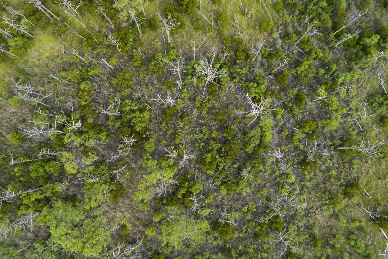
The state of Maryland has a separate $1.2 million restoration project backed by residents: installing physical barriers along Deal Island’s western shoreline so that water surges from the part of the bay known as Tangier Sound are slowed before they come ashore. The fear is that without such barriers, the water will eventually reach so far inland that it permanently merges with one of several large ponds. The water’s salt is already killing trees throughout the peninsula as the bay encroaches farther inward, creating needleless skeletal trunks nicknamed “ghost forests.”

That plan to build breakwaters, however, will rely on state funding — a precarious position given that Maryland, although the richest state in the nation, is not shielded from budget shortfalls. In September, the state agreed to a $70,000 grant in Somerset County as part of the project, which could begin in early 2019.
A spokeswoman for Gov. Larry Hogan says he remains committed to funding such efforts, including combatting climate change. Hogan invested $540,000 in new funding for the 2018 budget as part of bay restoration efforts spearheaded by the state Department of Natural Resources.
Sasha Land, a coastal training program coordinator with the department, says that absent any unforeseen flooding disaster, residents will have to figure out when the time is right for them to leave Deal. Right now, no one’s talking about buying residents out.
“This is the time to think about pre-disaster planning — what are you going to do before a catastrophe?” Land says. “Homeowners have a decision to make for what happens to their private property.”
Paradise Lost?
When University of Maryland researchers assess what many residents have told them, it’s this: They don’t want to leave, they don’t want the government to tell them they should leave and they want to maintain their way of life for as long as they can.
“A large portion of people’s mentality is that they believe leaving is an individual decision. A lot of people are very independent,” says Katherine J. Johnson, a Maryland anthropologist who was working on the project during the summer.
Deal Island dangles on the map like an open lobster claw. It was known as Devil’s Island in the 1600s — a name associated with pirates — before Methodists flocked to the island and the neighboring peninsula and rebranded it a more wholesome habitat.
Historically, there were no building codes in the community, and people developed as they saw fit. The land was ripe for cattle grazing, and in the late 1800s, the sea was a refuge for boat builders who could hammer out 50-foot-long vessels known as skipjacks, which are still a source of local pride and used for oyster dredging.
Today, a two-lane road ribbons through the cloistered countryside and curls along the shoreline. A bridge connects to the mainland. There’s a post office and a school, but the land is untouched by strip malls or Starbucks.
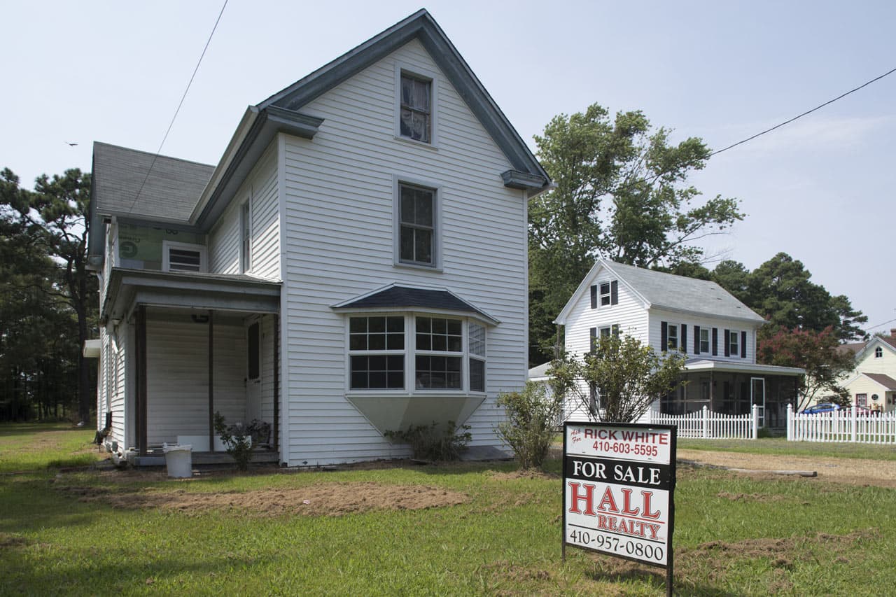

Many low-lying homes are on cement blocks in the event of flooding. Some homes have “for sale” signs out front. Others appear abandoned, the yards gnarly and overgrown.
Why are they vacant?
In recent years, the Federal Emergency Management Agency has revised the amount of land in the county that resides in a floodplain. A February 2015 letter from Somerset County commissioners to the state’s senators in Washington and a local elected official noted an alarming situation: “Approximately 53% of the County’s entire land area is located within the 100-year floodplain, including approximately 1,000 residences.”
That year, more than 10,000 additional acres were added to the floodplain from just four years earlier, the letter continued. “Based on recent news reports concerning climate change, an increase may not have been totally unexpected, but what is unexpected is the magnitude of the increase and that surrounding counties did not seem to experience the same type of increase as Somerset County did. … We understand that FEMA’s maps generally show an increased amount of floodplains along the Chesapeake Bay … but the impact on Somerset County appears especially severe,” the letter said.
The commissioners told the lawmakers that they were afraid residents’ flood insurance premiums would increase and that homeowners would be ill-equipped to pay, spurring a rise in foreclosures.
Whether that sort of spike is materializing remains unclear.
But the “for sale” signs are cropping up in the Deal Island neighborhood where Monica Princiotta and her husband, Bill, own waterfront property. Their picket-fenced vacation home overlooking a nature preserve and more than a mile of beach has come at a cost: As the shoreline has eroded since they bought the house in 2013, they have had to pour $50,000 into bolstering the bulkhead and riprap, a formation of large rocks used to protect the soil from erosion.
“This has washed away substantially,” Princiotta says, pointing to one side of her property that faces the meager strip of sand where the riprap is falling into the water. “You can barely get onto the beach now.”
In the 1920s and `30s, there used to be a dirt road that continued south on her street before it eroded. It is no more. A neighbor in June listed their home for $293,500. It sold two months later, but for $8,500 less.
The peril that erosion poses is a compelling reason for people to sell — but having to keep up homes in harsh weather conditions is also financially draining.
“People most likely cannot afford to maintain them, so either they sell or let them go into foreclosure,” says Princiotta, 55, who works for a health care company and spends part of the year in North Carolina.
But she and her husband have no plans to desert a home they hope to retire to someday. Besides, they’ve sunk so much money into shoring it up that when they sit in their deck chairs and watch the surrounding bay waters heave hypnotically before them, the idea that Deal could no longer exist seems unbelievable.
Princiotta lights up: “It is gorgeous here.”
Building a Bridge
In their efforts to chart a course for Deal’s future, academic researchers have steered delicately: They would have run into headwinds if they merely foisted the science behind the changing climate on residents.
That’s because the local culture is strong — and wary. Residents generally fall into two camps: the “born-heres” and the “come-heres.” Those with long-lasting generational ties typically align conservative in their politics. While Democrat Hillary Clinton kept Maryland blue in 2016, carrying its urban centers, Republican Donald Trump was handed a victory in the more rural pockets, including Somerset County.
The median household income in Maryland was about $70,000 in 2014, the highest in the nation, census data shows. But Somerset County is the poorest in the state, with a median household income of less than $37,000.
When people — outsiders — grumble about climate change, and in particular, how humans are responsible, it turns into a conversational roadblock for those born here. There are more pressing concerns, they say: How will I pay my mortgage? My medication? The fuel for my boat?
Pouring tens of thousands of dollars into protecting a home from an impending hurricane is one thing, but staving off the effects of a disaster that is decades away sounds like a downright luxury for many residents who are just scratching by.
These opposing viewpoints surface during a coffee klatch one afternoon at the home of Nancy and John Goldsmith. They are “come-heres,” having lived in the section of the peninsula called Dames Quarter since 1985, drawn by the quiet and the community.
Scientists estimate that hundreds of islands, including about 40 that were once inhabited, have slipped below the Chesapeake’s waters in the last 400 years. Since the 1970s alone, about 20 feet of shoreline near the Goldsmith’s waterview property has eroded.
“We’ve seen so many disappear,” Nancy Goldsmith, 75, a former public school educator from Long Island, New York, says of the islands. “To think that this one is going to be any different is foolish.”
Johnson, the University of Maryland researcher, and a colleague, Elizabeth Van Dolah, listen as Goldsmith laments that many residents can talk about flooding but want to bury their heads when “climate change” is uttered. If she had her way, forestalling Deal’s demise would be a top priority.
But Andrew Webster, a local historian and a “born-here” who is joining the Goldsmiths for lunch, is among the skeptics. He’s not so sure humans are driving the change in the climate so precipitously. As a practicing Methodist, a religion with roots here dating to the 1800s, he looks at the issue through the optics of faith.
“Human activity is a component of it, but a lot of people are skeptical that it’s the majority of what’s behind it,” Webster says. The researchers, he adds, “could have torpedoed this project if they came in browbeating the community.”
How the Global Average Sea Level Has Risen Cumulative sea level change from 1880 to 2014

12
10
Trend based on tide gauges with uncertainty
8
6
Inches
4
2
0
Year
-2
1880
1900
1920
1940
1960
1980
2000
2020

12in
Trend based on tide gauges with uncertainty
10
8
6
4
2
0
Year
-2
1880
2020
Even if residents clash on the origins of climate change, they acknowledge that their future is better served if they can come together.
Just south of Deal Island is Smith Island — the only island in Maryland with no bridge to the mainland. After Superstorm Sandy swamped Smith in October 2012, the state proposed buying out 10 homeowners the following year. But its 240 residents — fearing it was the beginning of the end — took a united front and formed a grass-roots group to reject being bought out by the government. Their resistant approach stands in contrast to the way members of the Louisiana bayou community of Isle de Jean Charles, which has lost 98 percent of its land, are being moved and resettled as part of a $48 million federal housing grant.
On Smith, the call to action was a success: Instead of buyouts, the U.S. Army Corps of Engineers has greenlighted a $9 million project to combat island erosion by building jetties. Work could begin this November.
But not every island has seen such a tangible response.
In his 2005 book, “The Disappearing Islands of the Chesapeake,” marine scientist William B. Cronin described how one weather-battered strip of land in the bay known as Holland Island collapsed, turning residents into “environmental refugees.”
“Island men worked the surrounding waters, dredging for oysters in winter and crabbing during the summer,” Cronin wrote. “Families raised much of their own food, with enough left over in good years to send to mainland markets. A few kept stores that supplied islanders’ daily needs.”
The same could be said for Deal. The final 20 acres representing Holland Island succumbed to the waters in 2010 after a nasty storm, leaving only a two-story Victorian home as the last structure left peeking out from the bay’s surface.
“Holland Island’s settlement, abandonment and gradual disappearance does not, sad to say, represent a unique occurrence in the history of the Chesapeake,” Cronin wrote. “As history tells us, more must certainly follow.”
At the Water’s Mercy
In 2011, Hurricane Irene howled across the Chesapeake coastline with 85-mph wind gusts.
At Arby Holland’s store, his wife, Debbie, recalls watching as the water from the bay thrashed the indoors. Four-foot waves pounded the shore. “It was filling up all these crab shanties,” she says, nodding toward makeshift structures along the bayfront where watermen keep blue crabs in containers of water, waiting for the crustaceans to emerge cocoon-like from their hardened shells.

The following year, Superstorm Sandy nearly flooded out Arby’s again.
“Water came right here to these top steps,” says employee Deborah Woollen, as men file in and out to stock up on blood worms, hooks and cases of orange Gatorade.
Woollen and her husband left the bustle of Baltimore 15 years ago for the sea and serenity. Inside Arby’s, talk turns to how weeks earlier Trump had called the mayor of Tangier Island, which sits in the Chesapeake about 12 miles from the Virginia coastline, to assure him that his sinking community would be there for hundreds of years. Woollen says she wishes she could have the president’s ear. Maybe he would want to hear how scientists say Deal, like Tangier, will vanish.
“He’s got other priorities,” Woollen reasons. “But if I could sit down with him, I would let him know.”
Decades from now, will a historian write about Deal and describe how residents rallied together to try to save it? This place — a secluded sanctuary where kids learn to swim in the bay waters, a new Miss SkipJack is crowned each year and families gather every Labor Day to watch white-hulled ships race. Some of the watermen concede that their futures on Deal remain fraught.
Dave Webster, a Methodist pastor who goes by “Dave Dave,” says he’s the last of five generations of watermen in his family. During his 40 years in the business, pulling in $2,800 in a good day last season, his children have all found jobs in other professions. One is a nurse, another is in IT, and a third is a school teacher.
“We worked them hard as kids, but they realized it’s not sustainable,” Webster, 60, says in a unique Southern-like drawl common in this part of Maryland’s Eastern Shore.
About 45 boats compete for crabs these days, but he remembers when there were hundreds. On the mainland, people might not relate to the lives of these watermen, but Webster marvels at how he can still work from sunup to sundown with his hands, foraging for food that can fill hungry bellies halfway around the world. He is a link — infinitesimal but important — in the global food chain.
The idea of forsaking Deal Island as he nears retirement makes Webster shake his head — not in disbelief, but in defiance.
“They say all this will be underwater in 2050,” he says. “We’ll see.”
His domain, this untameable water, unfolds before him on a day that shows no sign of a brewing tempest or a slow rising that will overtake the ground he stands on. There is only a faint breeze, and the day’s catch calling out.


