

ATHA Energy Angilak 2024 Exploration Update: First Six Holes Successfully Expand Footprint of Uranium Mineralization With 100% Hit Rate Outside of Historic Resource
/EIN News/ -- HIGHLIGHTS:
- Angilak Project: The Angilak Project is host to the Lac 50 Uranium Deposit, which is one of the largest high-grade deposits outside of the Athabasca Basin, with a historical mineral resource estimate of 43.3M lbs at an average grade of 0.69% U3O8.1
- In 2023, drilling at Angilak by Latitude Uranium (acquired by ATHA) intersected grades of up to 7.54 % U3O8 over 1.6 m.
- The 2024 Angilak Exploration Program is part of the Company’s overall 2024 Exploration Program and consists of Phase I (diamond drilling) and Phase II (geophysics & ground geochemistry).
- A ~10,000 m diamond drilling program targeting expansion of uranium mineralization along the Lac 50 Trend, proximal to the historic deposit, began on June 3rd, 2024.
- As of the end of June, six holes have been drilled outside the historic Lac 50 Mineral Resource footprint and successfully intersected uranium mineralization, demonstrating the expansion potential at the Angilak Project
- These six holes represent the beginning of the 2024 Angilak Exploration Program, with more than 7,000 m of ongoing drilling remaining
- Drilling highlights:
- All six holes successfully expanded the footprint of uranium mineralization at the Main Zone, Eastern Extension, and the J4 & Ray Zones, which represent the historic zone of mineralization at the Lac 50 Deposit
- The six holes targeted parallel Tuff Horizons that were first identified by Latitude Uranium. At the Main Zone and the Ray Zone, shallow (<150 m depth) high-grade uranium mineralization was intersected within these newly defined Tuff Horizons.
- These shallow, high-grade intersections provide evidence supporting the Company’s thesis that the Lac 50 Trend hosts a stacked lens system similar to basement-hosted uranium deposits in the Athabasca Basin, such as Cameco’s Eagle Point Mine.
- Drill hole MZ-DD-175 successfully intersected uranium mineralization 80 m along strike to the west of the Main Zone at the Lac 50 Deposit, as well as intersecting four additional parallel Tuff Horizons. Highlights include:
- Intersected Tuff MZ_004, which returned intermittent radioactivity (representative of uranium mineralization) from ~75 m to ~84.5 m depth with an average 1,685 counts per second (“CPS”) over 9.5 m and a peak of 21,940 CPS over 0.1 m. Uranium mineralization was also intersected in four additional intervals, including Tuff MZ_001 between ~366 m to ~375 m depth, where the hole intersected intermittent mineralization averaging 1,736 CPS over 9.0m and a peak of 9,026 CPS over 0.1 m.
- Drill hole J4R-DD-085 successfully intersected uranium mineralization down-dip from Tuff J4R_001 in the J4 Zone at the Lac 50 Deposit in addition to intersecting two other parallel Tuff Horizons (Tuff J4R_002 and Tuff J4R_003). Highlights include:
- Intersected Tuff J4R_003, which returned mineralization from 111.5 m to 113 m depth with an average 14,248 counts per second (CPS) over 1.5 m and a peak of 70,823 CPS over 0.1 m. Uranium mineralization was also intersected in two additional intervals, including Tuff J4R_002 between ~426 m to ~429.5 m depth where the hole intersected intermittent mineralization averaging 4,944 CPS over 3.5 m and a peak of 32,854 CPS over 0.1 m.
-
Phase II (geophysics & ground geochemistry): Scheduled to begin in August of 2024, ATHA will undertake a targeted airborne geophysics program comprised of electromagnetic (“EM”), Mag, and VLF survey types, in addition to targeted ground geochemistry sampling and mapping. The objective of Phase II is to identify and derisk a pipeline of additional high-priority targets for future exploration programs.
VANCOUVER, British Columbia, July 10, 2024 (GLOBE NEWSWIRE) -- ATHA Energy Corp. (TSX.V: SASK) (FRA: X5U) (OTCQB: SASKF) (“ATHA” or the “Company”), holder of the largest uranium exploration portfolio in two of the highest-grade uranium districts in the world, is pleased to announce radioactivity results from six diamond drill holes completed as part of the Company’s inaugural 2024 Angilak Exploration Program at its 100%-owned Angilak Project in Nunavut.
Phase I of the 2024 Angilak Exploration Program is comprised of approximately 10,000 m of diamond drilling targeting the expansion of high-grade uranium mineralization outside of the historic resource footprint at the Lac 50 Deposit. The initial six holes total 2,817.6 m and target the expansion of the Main Zone, Eastern Extension, and the J4 & Ray Zone along the Lac 50 Trend at the Lac 50 Deposit.
ANGILAK PROJECT – NUNAVUT
The Angilak Project is situated within the Angikuni Basin, approximately 225 km southwest of Baker Lake in the Kivalliq Region of Nunavut (Figure 1) and is host to the Lac 50 Uranium Deposit, which has a historical mineral resource estimate of 43.3M lbs at an average grade of 0.69% U3O8.1
ATHA’s 2024 Angilak exploration program consists of diamond drilling, airborne geophysical surveys, and surficial sampling and mapping programs that prioritize the expansion of the footprint of known uranium mineralization, while also advancing regional exploration targets. Approximately 10,000 m of diamond drilling is currently underway, focused on expansion of the historic footprint at the Lac 50 Deposit’s Main Zone, Western Extension, Eastern Extension, and J4 & Ray Zone, as well as expansion of the recently identified parallel mineralized Tuff Horizons. Diamond drilling will also test additional regional targets that have been identified through past exploration campaigns – the most recent of which was completed in the fall of 2023 by Latitude Uranium (“Latitude”) (acquired by ATHA). During Latitude’s most recent exploration program, the Company reported uranium drill hole intersections targeting the Main Zone showing grades of up to 7.54 % U3O8 over 1.6 m from hole 23-LC-005.
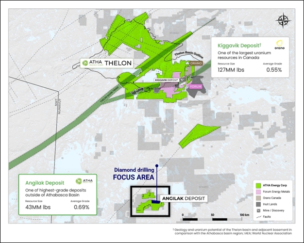
Figure 1: Plan Map detailing the Angilak Project location within Nunavut1
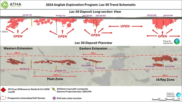
Figure 2: Lac 50 Trend Schematic, displaying drill hole traces, historic resource shells, and prospective mineralized Tuff Horizon
Main Zone
The Main Zone at the Lac 50 Deposit has a historically defined mineralized footprint with a strike length of approximately 1,500 m and depth of 340 m. The uranium mineralization within the historic mineral resource is restricted to one lens. Additional drilling completed by Latitude Uranium intersected extensive mineralization outside of the historic resource. Recent geological interpretation and modeling of the additional mineralization demonstrates the Main Zone - along with the Western Extension, Eastern Extension, and J4 & Ray Zones – is part of a stacked lens system associated with Tuff Horizons. Tuff MZ_001, represents the bulk of the historic resource at the Main Zone, with Tuff MZ_002 through to Tuff MZ_005 representing newly defined parallel lenses of uranium mineralization.
Drill hole MZ-DD-174 was designed to test the down-plunge extent of uranium mineralization in Tuff MZ_001, as well as testing the extensions of additional newly defined Tuff Horizons. The hole was completed to a total depth of 600 m and successfully intersected Tuff MZ_001, 002, 003, 005, as well as a new shallow lens of uranium mineralization between 31 m and 32.5 m depth.
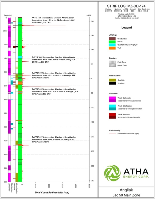
Figure 3: Strip log detailing results from drill hole MZ-DD-174 located at the Main Zone of the Lac 50 Deposit. The Strip log displays radioactivity derived from a 40TGU Triple Gamma Probe which measures radioactivity every 10 cm. Depth intervals mentioned are approximate (~) corresponding to 0.5 m intervals, and have been corrected to radioactivity observed in drill core via an RS-120 scintillometer.
Drill hole MZ-DD-175 was designed to test the strike extent of mineralization between the Western Extension and the Main Zone of the Lac 50 Deposit, targeting the extension of Tuff MZ_001 as well as other parallel Tuff Horizons. The hole was completed to a total depth of 471 m and successfully intersected Tuff MZ_001, 002, 003, and 004.
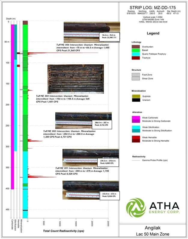
Figure 4: Strip log detailing results from drill hole MZ-DD-175 located at the Main Zone of the Lac 50 Deposit. The Strip log displays radioactivity derived from a 40TGU Triple Gamma Probe which measures radioactivity every 10 cm. Depth intervals mentioned are approximate (~) corresponding to 0.5 m intervals, and have been corrected to radioactivity observed in drill core via an RS-120 scintillometer.
J4 & Ray Zones
The J4 and Ray Zones are situated approximately 1,800 m along strike to the southeast of the Main Zone at the Lac 50 Deposit and have a historically defined mineralized footprint with a strike length of approximately 920 m and depth of 420 m. The uranium mineralization within the historic resource is restricted to two lenses: Tuff J4R_001 – representing the bulk of the historic resource at the J4 Zone – and Tuff J4R_003 – representing the bulk of the historic resource in the Ray Zone. Tuff lenses J4R_002 and J4R_004 are newly defined Tuff horizons with associated mineralization.
Drill hole J4R-DD-085 was designed to test the down-plunge extent of mineralization at the J4 & Ray Zones of the Lac 50 Deposit along with testing for additional lenses of parallel mineralization. The hole was completed to a depth of 490.8 m and successfully intersected mineralization, extending mineralization associated with Tuff J4R_001 between ~451.5 m and ~459 m, Tuff J4R_002 from ~426 m to ~429.5 m, and Tuff J4R_003 from ~111.5 m to ~113 m.
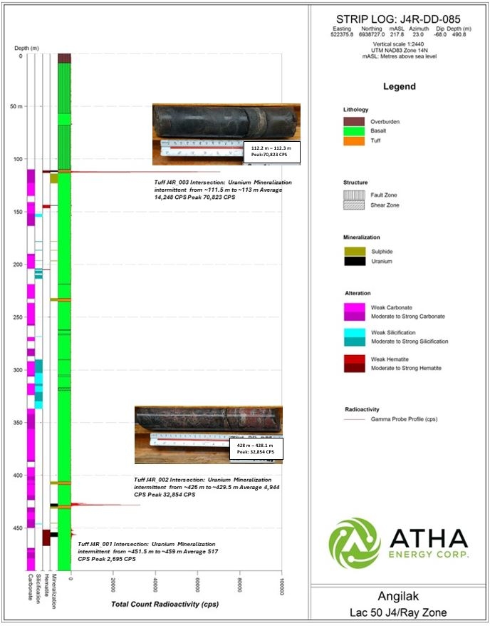
Figure 5: Strip log detailing results from drill hole J4R-DD-085 located at the J4 & Ray Zones of the Lac 50 Deposit. The Strip log displays radioactivity derived from a 40TGU Triple Gamma Probe which measures radioactivity every 10 cm. Depth intervals mentioned are approximate (~) corresponding to 0.5 m intervals, and have been corrected to radioactivity observed in drill core via an RS-120 scintillometer.
J4R-DD-086 was designed to test the eastern strike extent of mineralization in the Ray Zone and the down-dip extension of mineralization in the J4 Zone, as well as testing for additional lenses of parallel mineralization. The hole was completed to a depth of 468.5 m and successfully intersected mineralization, extending Tuff J4R_002 associated mineralization between ~390.5 m and ~392 m, Tuff J4R_003 with associated intermittent mineralization from ~84.5 m to ~92.5 m, and Tuff J4R_004 with associated mineralization from ~35 m to ~36 m.
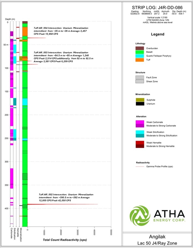
Figure 6: Strip log detailing results from drill hole J4R-DD-086 located at the J4 & Ray Zones of the Lac 50 Deposit. The Strip log displays radioactivity derived from a 40TGU Triple Gamma Probe which measures radioactivity every 10 cm. Depth intervals mentioned are approximate (~) corresponding to 0.5 m intervals, and have been corrected to radioactivity observed in drill core via an RS-120 scintillometer.
Eastern Extension
The Eastern Extension is situated approximately 350 m along strike to the northeast of the Main Zone at the Lac 50 Deposit and has a historically defined mineralized footprint with a strike length of approximately 700 m and depth of 320 m. The uranium mineralization within the historic resource is restricted to one lens currently identified as Tuff EX_001. Although mineralization has been encountered outside of the Tuff EX_001 horizon, additional lenses of mineralization have not yet been defined.
Drill holes EEX-DD-052 and EEX-DD-053 were designed to test the down plunge extent of mineralization within the Eastern Extension Tuff EX_001 lens. Both holes were successful in extending the Tuff EX_001 associated mineralized footprint with intersections from 374 m to 376m and 305m to 307m, in EEX-DD-052 and EEX-DD-053, respectively. Both holes also intersected additional mineralized structures within the hanging-wall of the Tuff EX_001 lens, as depicted in Figures 6 and 7. Drill holes EEX-DD-052 and EEX-DD-053 were drilled to final depths of 427.3m and 360m, respectively.
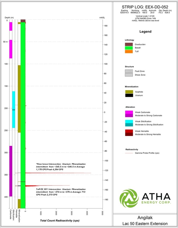
Figure 6: Strip log detailing results from drill hole EEX-DD-052 located at the Eastern Extension of the Lac 50 Deposit. The Strip log displays radioactivity derived from a 40TGU Triple Gamma Probe which measures radioactivity every 10 cm. Depth intervals mentioned are approximate (~) corresponding to 0.5 m intervals, and have been corrected to radioactivity observed in drill core via an RS-120 scintillometer.
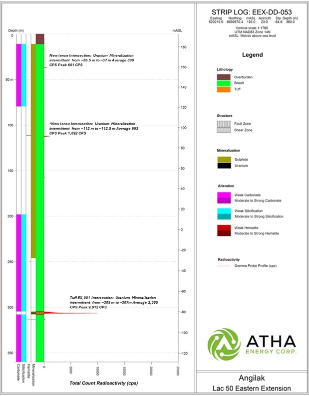
Figure 7: Strip log detailing results from drill hole EEX-DD-053 located at the Eastern Extension of the Lac 50 Deposit. The Strip log displays radioactivity derived from a 40TGU Triple Gamma Probe which measures radioactivity every 10 cm. Depth intervals mentioned are approximate (~) corresponding to 0.5 m intervals, and have been corrected to radioactivity observed in drill core via an RS-120 scintillometer.
Table 1: 2024 drill hole collar and orientation details for drill holes completed on Main Zone, Eastern Extension, J4 and Ray zones as of the end of June.
| Hole ID | Zone | Azimuth (⁰) | Dip (⁰) | Easting (mE) | Northing (mN) | Elevation (m) | End of Hole (m) |
| MZ-DD-174 | Main Zone | 25.0 | -78.6 | 518907.4 | 6939921.0 | 214.85 | 600.0 |
| MZ-DD-175 | Main Zone | 25.0 | -50.0 | 518103.8 | 6940337.7 | 230.00 | 471.0 |
| EEX-DD-052 | Eastern Extension | 25.0 | -70.2 | 520314.0 | 6939522.3 | 193.00 | 427.3 |
| J4R-DD-085 | J4-Ray | 23.0 | -68.0 | 522375.8 | 6938727.0 | 217.84 | 490.8 |
| EEX-DD-053 | Eastern Extension | 23.0 | -65.0 | 520219.9 | 6939570.4 | 192.99 | 360.0 |
| J4R-DD-086 | J4-Ray | 25 | -50 | 522602.8 | 6938606 | 207.22 | 468.5 |
Troy Boisjoli, CEO added: “The first six drill holes from ATHA's inaugural drill program at the Angilak Project in Nunavut confirms the significant potential for expansion of the known zones of mineralization along the Lac 50 Trend along with demonstrating the high probability of additional discoveries. The 100% hit rate for these holes, on substantial step outs, is extremely encouraging and speaks to the robust nature of the mineralizing system at play at our Angilak Project. The results help confirm ATHA's thesis, that Nunavut has exploration potential analogous to the Athabasca Basin with respect to substantial uranium discoveries. Coming at a time when the macro case for Uranium has never been better, particularly for high-grade assets in proven stable jurisdictions.”
Cliff Revering, VP Exploration added: “Drilling results to date have been very encouraging and demonstrate the exciting expansion potential of uranium mineralization within the Lac 50 deposit. As we progress through our 2024 exploration program and strategy, we will continue to develop our understanding of this relatively under-explored and highly prospective uranium district.”
Qualified Person
The scientific and technical information contained in this news release have been reviewed and approved by Cliff Revering, P.Eng., Vice President, Exploration of ATHA, who is a "qualified person" as defined under National Instrument 43-101 – Standards of Disclosure for Mineral Projects.
About ATHA
ATHA is a Canadian mineral company engaged in the acquisition, exploration, and development of uranium assets in the pursuit of a clean energy future. With a strategically balanced portfolio including three 100%-owned post discovery uranium projects (the Angilak Project located in Nunavut, and CMB Discoveries in Labrador hosting historical resource estimates of 43.3 million lbs and 14.5 million lbs U3O8 respectively, and the newly discovered basement hosted GMZ high-grade uranium discovery located in the Athabasca Basin). In addition, the Company holds the largest cumulative prospective exploration land package (8.4 million acres) in two of the world’s most prominent basins for uranium discoveries - ATHA is well positioned to drive value. ATHA also holds a 10% carried interest in key Athabasca Basin exploration projects operated by NexGen Energy Ltd. and IsoEnergy Ltd. For more information visit www.athaenergy.ca.1,2,3.
For more information, please contact:
Troy Boisjoli
Chief Executive Officer
Email: info@athaenergy.ca
www.athaenergy.ca
Historical Mineral Resource Estimates
All mineral resources estimates presented in this news release are considered to be “historical estimates” as defined under NI 43-101, and have been derived from the following (See notes below). In each instance, the historical estimate is reported using the categories of mineral resources and mineral reserves as defined by the CIM Definition Standards for Mineral Reserves, and mineral reserves at that time, and these “historical estimates” are not considered by ATHA to be current. In each instance, the reliability of the historical estimate is considered reasonable, but a Qualified Person has not done sufficient work to classify the historical estimate as a current mineral resource, and ATHA is not treating the historical estimate as a current mineral resource. The historical information provides an indication of the exploration potential of the properties but may not be representative of expected results.
Notes on the Historical Mineral Resource Estimate for the Angilak Deposit:
- This estimate is considered to be a “historical estimate” under NI 43-101 and is not considered by any of to be current. See below for further details regarding the historical mineral resource estimate for the Angilak Property.
- Mineral resources which are not mineral reserves do not have demonstrated economic viability.
- The estimate of mineral resources may be materially affected by geology, environment, permitting, legal, title, taxation, sociopolitical, marketing or other relevant issues.
- The quality and grade of the reported inferred resource in this estimation are uncertain in nature and there has been insufficient exploration to define these inferred resources as an indicated or measured mineral resource, and it is uncertain if further exploration will result in upgrading them to an indicated or measured resource category.
- Contained value metals may not add due to rounding.
- A 0.2% U3O8 cut-off was used.
- The mineral resource estimate contained in this press release is considered to be “historical estimates” as defined under NI 43-101 and is not considered to be current.
- The “historical estimate” is derived from a Technical Report entitled “Technical Report and Resource Update For The Angilak Property, Kivalliq Region, Nunavut, Canada”, prepared by Michael Dufresne, M.Sc., P.Geol. of APEX Geosciences, Robert Sim, B.Sc., P.Geo. of SIM Geological Inc. and Bruce Davis, Ph.D., FAusIMM of BD Resource Consulting Inc., dated March 1, 2013 for ValOre Metals Corp.
- As disclosed in the above noted technical report, the historical estimate was prepared under the direction of Robert Sim, P.Geo, with the assistance of Dr. Bruce Davis, FAusIMM, and consists of three-dimensional block models based on geostatistical applications using commercial mine planning software. The project limits area based in the UTM coordinate system (NAD83 Zone14) using nominal block sizes measuring 5x5x5m at Lac Cinquante and 5x3x3 m (LxWxH) at J4. Grade (assay) and geological information is derived from work conducted by Kivalliq during the 2009, 2010, 2011 and 2012 field seasons. A thorough review of all the 2013 resource information and drill data by a Qualified Person, along with the incorporation of subsequent exploration work and results, which includes some drilling around the edges of the historical resource subsequent to the publication of the 2013 technical report, would be required in order to verify the Angilak Property historical estimate as a current mineral resource.
- The historical mineral resource estimate was calculated in accordance with NI 43-101 and CIM standards at the time of publication and predates the current CIM Definition Standards for Mineral Resources and Mineral Reserves (May, 2014) and CIM Estimation of Mineral Resources & Mineral Reserves Best Practices Guidelines (November, 2019).
- A thorough review of all historical data performed by a Qualified Person, along with additional exploration work to confirm results would be required to produce a current mineral resource estimate prepared in accordance with NI 43-101.
-
Notes on the Historical Mineral Resource Estimate for the Moran Lake Deposit:
- Jeffrey A. Morgan, P.Geo. and Gary H. Giroux, P.Eng. completed a NI 43-101 technical report titled “Form 43-101F1 Technical Report on the Central Mineral Belt (CMB) Uranium Project, Labrador, Canada, Prepared for Crosshair Exploration & Mining Corp.” and dated July 31, 2008, with an updated mineral resource estimate for the Moran Lake C-Zone along with initial mineral resources for the Armstrong and Area 1 deposits. They modelled three packages in the Moran Lake Upper C-Zone (the Upper C Main, Upper C Mylonite, and Upper C West), Moran Lake Lower C-Zone, two packages in Armstrong (Armstrong Z1 and Armstrong Z3), and Trout Pond. These mineral resources are based on 3D block models with ordinary kriging used to interpolate grades into 10 m x 10 m x 4 m blocks. A cut-off grade of 0.015% U3O8 was used for all zones other than the Lower C Zone which employed a cut-off grade of 0.035%. A thorough review of all historical data performed by a Qualified Person, along with additional exploration work to confirm results, would be required to produce a current mineral resource estimate prepared in accordance with NI 43-101 standards.
3. Notes on the Historical Mineral Resource Estimate for the Anna Lake Deposit:
- The mineral resource estimate contained in this table is considered to be a “historical estimate” as defined under NI 43-101, and is not considered to be current and is not being treated as such. A Qualified Person has not done sufficient work to classify the historical estimate as current mineral resources. A qualified person would need to review and verify the scientific information and conduct an analysis and reconciliation of historical drill and geological data in order to verify the historical estimate as a current mineral resource.
- Reported by Bayswater Uranium Corporation in a Technical Report entitled “Form 43-101 Technical Report on the Anna Lake Uranium Project, Central Mineral Belt, Labrador, Canada”, prepared by R. Dean Fraser, P.Geo. and Gary H. Giroux, P.Eng., dated September 30, 2009.
- A 3-dimensional geologic model of the deposit was created for the purpose of the resource estimate using the Gemcom/Surpac modeling software. A solid model was created using a minimum grade x thickness cutoff of 3 meters grading 0.03% U3O8. Intersections not meeting this cutoff were generally not incorporated into the model. The shell of this modeled zone was then used to constrain the mineralization for the purpose of the block model. Assay composites 2.5 meters in length that honoured the mineralized domains were used to interpolate grades into blocks using ordinary kriging. An average specific gravity of 2.93 was used to convert volumes to tonnes. The specific gravity data was acquired in-house and consisted of an average of seventeen samples collected from the mineralised section of the core. The resource was classified into Measured, Indicated or Inferred using semi-variogram ranges applied to search ellipses. All resources estimated at Anna Lake fall under the “Inferred” category due to the wide spaced drill density. An exploration program would need to be conducted, including twinning of historical drill holes in order to verify the Anna Lake Project estimate as a current mineral resource.
Cautionary Statement Regarding Forward-Looking Information
This press release contains “forward-looking information” within the meaning of applicable Canadian securities legislation. Generally, forward-looking information can be identified by the use of forward-looking terminology such as “plans”, “expects” or “does not expect”, “is expected”, “budget”, “scheduled”, “estimates”, “forecasts”, “intends”, “anticipates” or “does not anticipate”, or “believes”, or variations of such words and phrases or state that certain actions, events or results “may”, “could”, “would”, “might” or “will be taken”, “occur” or “be achieved”. These forward-looking statements or information may relate to ATHA’s proposed exploration program, including statements with respect to the expected benefits of ATHA’s proposed exploration program, any results that may be derived from ATHA’s proposed exploration program, the timing, scope, nature, breadth and other information related to ATHA’s proposed exploration program, any results that may be derived from the diversification of ATHA’s portfolio, the successful integration of the businesses of ATHA, Latitude Uranium and 92 Energy, the prospects of ATHA’s projects, including mineral resources estimates and mineralization of each project, the prospects of ATHA’s business plans and any expectations with respect to defining mineral resources or mineral reserves on any of ATHA’s projects, and any expectation with respect to any permitting, development or other work that may be required to bring any of the projects into development or production.
Forward-looking statements are necessarily based upon a number of assumptions that, while considered reasonable by management at the time, are inherently subject to business, market and economic risks, uncertainties and contingencies that may cause actual results, performance or achievements to be materially different from those expressed or implied by forward-looking statements. Such assumptions include, but are not limited to, assumptions that the anticipated benefits of ATHA’s proposed exploration program will be realized, that no additional permit or licenses will be required in connection with ATHA’s exploration programs, the ability of ATHA to complete its exploration activities as currently expected and on the current anticipated timelines, including ATHA’s proposed exploration program, that ATHA will be able to execute on its current plans, that ATHA’s proposed explorations will yield results as expected, the synergies between ATHA, 92 Energy and Latitude Uranium’s assets, and that general business and economic conditions will not change in a material adverse manner. Although each of ATHA and 92E have attempted to identify important factors that could cause actual results to differ materially from those contained in forward-looking information, there may be other factors that cause results not to be as anticipated, estimated or intended. There can be no assurance that such information will prove to be accurate, as actual results and future events could differ materially from those anticipated in such statements. Accordingly, readers should not place undue reliance on forward-looking information.
Such statements represent the current view of ATHA with respect to future events and are necessarily based upon a number of assumptions and estimates that, while considered reasonable by ATHA, are inherently subject to significant business, economic, competitive, political and social risks, contingencies and uncertainties. Risks and uncertainties include, but are not limited to the following: inability of ATHA to realize the benefits anticipated from the exploration and drilling targets described herein or elsewhere; in ability of ATHA to complete current exploration plans as presently anticipated or at all; inability for ATHA to economically realize on the benefits, if any, derived from the exploration program; failure to complete business plans as it currently anticipated; overdiversification of ATHA’s portfolio; failure to realize on benefits, if any, of a diversified portfolio; unanticipated changes in market price for ATHA shares; changes to ATHA’s current and future business and exploration plans and the strategic alternatives available thereto; growth prospects and outlook of the business of ATHA; any impacts of COVID-19 on the business of ATHA and the ability to advance the Company projects and its proposed exploration program; risks inherent in mineral exploration including risks related worker safety, weather and other natural occurrences, accidents, availability of personnel and equipment, and other factors; aboriginal title; failure to obtain regulatory and permitting approvals; no known mineral resources/reserves; reliance on key management and other personnel; competition; changes in laws and regulations; uninsurable risks; delays in governmental and other approvals, community relations; stock market conditions generally; demand, supply and pricing for uranium; and general economic and political conditions in Canada, Australia and other jurisdictions where ATHA conducts business. Other factors which could materially affect such forward-looking information are described in the filings of ATHA with the Canadian securities regulators which are available on ATHA’s profile on SEDAR+ at www.sedarplus.ca. ATHA does not undertake to update any forward-looking information, except in accordance with applicable securities laws.
Photos accompanying this announcement are available at:
https://www.globenewswire.com/NewsRoom/AttachmentNg/dc12779d-a9d4-4771-80dd-3098b7656417
https://www.globenewswire.com/NewsRoom/AttachmentNg/e0e54d84-4aef-4539-9676-bf42232d24ac
https://www.globenewswire.com/NewsRoom/AttachmentNg/523d0e77-edd3-4c31-b3de-8e55ddc002a4
https://www.globenewswire.com/NewsRoom/AttachmentNg/c7d13742-c12d-43ca-be44-30d9df76a6b9
https://www.globenewswire.com/NewsRoom/AttachmentNg/8214ab3e-a756-434b-a2e7-43f0f7364fe7
https://www.globenewswire.com/NewsRoom/AttachmentNg/282d5ff6-7e01-42e2-8b0b-69a80d8c2c39
https://www.globenewswire.com/NewsRoom/AttachmentNg/28fd3243-7321-4ef7-aefd-c4dba80e9da8
https://www.globenewswire.com/NewsRoom/AttachmentNg/13a14fc7-f2a5-42c5-86ab-7d485c1cffc3

![]()
Figure 1

Plan Map detailing the Angilak Project location within Nunavut (1)
Figure 2

Lac 50 Trend Schematic, displaying drill hole traces, historic resource shells, and prospective mineralized Tuff Horizon
Figure 3

Strip log detailing results from drill hole MZ-DD-174 located at the Main Zone of the Lac 50 Deposit. The Strip log displays radioactivity derived from a 40TGU Triple Gamma Probe which measures radioactivity every 10 cm. Depth intervals mentioned are approximate (~) corresponding to 0.5 m intervals, and have been corrected to radioactivity observed in drill core via an RS-120 scintillometer.
Figure 4

Strip log detailing results from drill hole MZ-DD-175 located at the Main Zone of the Lac 50 Deposit. The Strip log displays radioactivity derived from a 40TGU Triple Gamma Probe which measures radioactivity every 10 cm. Depth intervals mentioned are approximate (~) corresponding to 0.5 m intervals, and have been corrected to radioactivity observed in drill core via an RS-120 scintillometer.
Figure 5:

Strip log detailing results from drill hole J4R-DD-085 located at the J4 & Ray Zones of the Lac 50 Deposit. The Strip log displays radioactivity derived from a 40TGU Triple Gamma Probe which measures radioactivity every 10 cm. Depth intervals mentioned are approximate (~) corresponding to 0.5 m intervals, and have been corrected to radioactivity observed in drill core via an RS-120 scintillometer.
Figure 6

Strip log detailing results from drill hole J4R-DD-086 located at the J4 & Ray Zones of the Lac 50 Deposit. The Strip log displays radioactivity derived from a 40TGU Triple Gamma Probe which measures radioactivity every 10 cm. Depth intervals mentioned are approximate (~) corresponding to 0.5 m intervals, and have been corrected to radioactivity observed in drill core via an RS-120 scintillometer.
Figure 6

Strip log detailing results from drill hole EEX-DD-052 located at the Eastern Extension of the Lac 50 Deposit. The Strip log displays radioactivity derived from a 40TGU Triple Gamma Probe which measures radioactivity every 10 cm. Depth intervals mentioned are approximate (~) corresponding to 0.5 m intervals, and have been corrected to radioactivity observed in drill core via an RS-120 scintillometer.
Figure 7

Strip log detailing results from drill hole EEX-DD-053 located at the Eastern Extension of the Lac 50 Deposit. The Strip log displays radioactivity derived from a 40TGU Triple Gamma Probe which measures radioactivity every 10 cm. Depth intervals mentioned are approximate (~) corresponding to 0.5 m intervals, and have been corrected to radioactivity observed in drill core via an RS-120 scintillometer.
EIN Presswire does not exercise editorial control over third-party content provided, uploaded, published, or distributed by users of EIN Presswire. We are a distributor, not a publisher, of 3rd party content. Such content may contain the views, opinions, statements, offers, and other material of the respective users, suppliers, participants, or authors.